Discussion of the issues that affect you on a local, provincial and federal level
Wednesday, September 16, 2026
Prescribed burn planned near Doc English Road (Riske Creek)
Monday, August 10, 2026
Off Road Vehicle use banned in 100 Mile House area....
![]() |
| ORV Prohibition marked in "red" |
Effective at 12 p.m. (noon) PT on August 10, 2026 – Effective immediately, Monday August 10, 2026, off-road vehicles (ORV) will be prohibited on Crown Land throughout the 100 Mile House Forest District which includes the entirety of Cariboo Regional District Electoral Areas "G", "H" and "L"
Given the scope and scale of fires currently burning in B.C., and the elevated danger ratings in many southern regions of the province, this prohibition is being put into place to further protect public safety.
As of Monday, August 10, 2026, the operation of any off-road vehicle for recreational purposes on Crown land will be prohibited and all on-highway vehicles must remain on road surfaces as defined in the Forest Planning and Practices Regulation.
The prohibition applies to off-road vehicles as defined in the Off-Road Vehicle Act and section 2 (a) of the Off-Road Vehicle Regulation:
- all-terrain vehicles
- motorcycles
- off road side-by-side vehicles
This prohibitions does not apply to private lands or national parks. It also does not apply to emergency response, agriculture or commercial/industrial users who operate off road vehicles for farming or business purposes.
This prohibition will remain in place until 12:00 noon Pacific Time October 9, 2026, or until the order is rescinded. The BC Wildfire Service is continually monitoring conditions and this prohibition may be expanded or rescinded as needed.
Reminder that wildfires are dynamic and conditions can change quickly. Before traveling, check the Prohibitions and Restrictions page for any area restrictions, and review DriveBC.ca for road impacts.
Report an off-road violation
To report a violation of the ORV prohibition, call the RAPP line at: 1 877 952-7277.
You can also digitally report a violation using the online reporting service.
Report a wildfire
The Cariboo Fire Centre would like to thank the public for its continuing help in preventing wildfires by:
- Dialing *5555 on a cell phone
- Calling 1 800 663-5555 toll-free
- Reporting through the BC Wildfire App with the Report a fire function
- Reporting through the app lets you upload images and can be used without service
Stay up-to-date with the latest wildfire news on:
- BCWildfire.ca
- BC Wildfire Map
- BC Wildfire App: Apple or Android
- Facebook and Instagram
- DriveBC
Tuesday, April 21, 2026
Category 2 and 3 open fire prohibitions coming into effect across the Cariboo Fire Centre
|
|
|
|
|
Monday, April 20, 2026
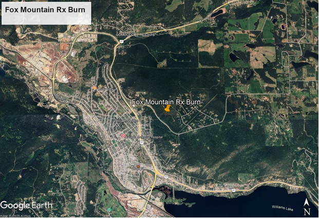
Prescribed burn planned for Fox Mountain area (Eider Drive area)
To reduce the threat of wildfire the BC Wildfire Service, in collaboration with the Williams Lake Fire Department, will conduct a wildfire risk reduction prescribed burn on Fox Mountain. This prescribed burn is a continuation of the 13 hectare fuel reduction treatment that was completed April 9, 2026.
When and where
- Burning will begin as early as Friday, April 24, continuing periodically until May 15.
- The prescribed burn will take place on approximately 20 hectares of land west of Eider Drive on the north side of Fox Mountain Road.

What to expect
- Smoke and flames will be visible to residents on Fox Mountain, from the City of Williams Lake and to motorists traveling Highway 97.
- Crews will ignite ground fuels to remove combustible materials.
- Ignitions will only proceed if conditions are safe, with favorable weather and atmospheric venting allowing smoke to clear quickly.
- While burning is underway portions of the Bearacouga Mountain Bike Trail will be restricted, signage will be placed on the trails as needed.
- While burning is underway, traffic control may be on site to ensure the safety of public and firefighters, short delays may occur.
- Personnel will remain on site until there is no risk of the fire spreading beyond the perimeter and return daily until the fire is out.
- Smoke from within the perimeter of the burn may be visible up to 72 hours after ignition.
These YouTube videos explain the benefits of prescribed burning and showcase the process and some of the work that goes into planning prescribed burns. The BCWS YouTube channel is an excellent resource to watch videos on wildfire and prevention in the province.
Objectives of this prescribed burn
- Reduce wildfire risk to the City of Williams Lake and surrounding area.
- Use fire to restore forest health to encourage a properly functioning ecosystem and maintain treatments from previous years.
- Strengthen collaboration between the Williams Lake Fire Department and the Cariboo Fire Centre to grow capacity and knowledge outside of emergency response situations.
Minimizing health impacts from smoke
Exposure to smoke from wildfires or prescribed burning can irritate eyes and respiratory tracts and worsen pre-existing lung and heart conditions. If your area is impacted by smoke:
- Manage pre-existing conditions and seek medical care if you have severe symptoms.
- Reduce the length and intensity of outdoor activities.
- Run portable air cleaners with windows and doors closed. Both commercial and home-made units (https://rb.gy/90uh5s) can be effective if operated properly.
Learn about protecting your health from smoke online: http://www.bccdc.ca/health-info/prevention-public-health/wildfire-smoke
Learn more
Fire is a natural process in many of B.C.’s ecosystems. The BC Wildfire Service works regularly with land managers to undertake fuel management activities, including the use of prescribed burns, to help reduce the severity of future wildfires and related threats to communities.
Learn more about prescribed burning online at prescribedfire.ca or find more resources here.
Reporting
- To report an unattended campfire or open burning violation calling call the RAPP line at 1-877-952-7277.
- To report illegal fires in a local fire department’s jurisdiction, call 9-1-1.
- Dial *5555 on a cell phone or call 1 800 663-5555 toll-free to report a wildfire.
- Use the Report function in the BC Wildfire App to report a wildfire. Reporting though the app lets you upload images and can be used without service.
Stay in the know
For the latest information on current wildfire activity, prohibitions and restrictions, road closures, and air-quality advisories please visit BCWildfire.ca, the BC Wildfire Map, or use the BC Wildfire app.
Follow the latest wildfire news on:
Contact
Fire Information Officer
Cariboo Fire Centre | BC Wildfire Service
778 799-2100
CaFCInfo@gov.bc.ca
Wednesday, March 25, 2026
Spring Fuel Treatments Planned at Multiple Locations Throughout Williams Lake
Prescribed burn planned for Fox Mountain area
Prescribed burn planned along Highway 20/Hanceville Area...
When and where
Burning is expected to begin as early as Friday, March 27, 2026 and may continue periodically until June 1, 2026
The prescribed burns will take place on approximately 20 hectares of land between Hanceville and Chilanko Forks, adjacent to Highway 20.
Ignitions will only proceed if conditions are safe, with favorable weather and atmospheric venting allowing smoke to clear quickly.
What to expect
Smoke and flames will be visible from Riske Creek, Tl'esqox, Tŝideldel, Yunesit’in, T’letinqox, Alexis Creek, Highway 20 and surrounding areas.
Crews will ignite ground fuels to remove combustible materials and mimic a naturally occurring wildland fire.
While burning is underway, traffic control will be on-site to ensure the safety of public and firefighters, short delays may occur.
Firefighters will closely monitor the fire activity at all times during the burn.
Personnel will remain on-site into the evening to ensure the burns are fully extinguished at the end of each day and will only leave once there is no risk of the fire spreading.
Smoke from within the perimeter of the burn may be visible up to 72 hours after ignition.
Objectives of this prescribed burn
Reduce wildfire risk along the Highway 20 corridor.
Reduce fire damage to highway, utility and range infrastructure.
Use fire to restore grassland and forest health to encourage a properly functioning ecosystem.
Strengthen collaboration between BC Wildfire Service and local communities outside of emergency response situation.
Learn more
Fire is a natural process in many of B.C.’s ecosystems. The BC Wildfire Service works regularly with land managers to undertake fuel management activities, including the use of prescribed burns, to help reduce the severity of future wildfires and related threats to communities.
Learn more about prescribed burning online at prescribedfire.ca or find more resources here.
Thursday, January 22, 2026
BC Wildfire Service prescribed burn planned for Dipping Road
When and where
Burning is expected to begin as early as Thursday, January 22, 2026, and continue periodically until Friday, February 13, 2026, as weather permits.
The prescribed burn will cover up to 20 hectares within the Williams Lake Community Forest.
Ignitions will proceed only if conditions are suitable and allow for smoke dissipation.
What to expect
Smoke may be visible from Williams Lake and surrounding areas, and to motorists travelling on Highway 20.
Low-to moderate-intensity spot fires will be lit within pre-established boundaries to remove combustible materials.
Firefighters will closely monitor the fire activity at all times during the burn.
Smoke from within the perimeter of the burn may be visible up to 72 hours after ignition.
Objectives of this prescribed burn
Continuing previous Wildfire Risk Reduction treatments to reduce juniper density and create a more fire resilient forest. This project is a continuation of a relationship with Williams Lake First Nation to grow capacity and knowledge for cultural and prescribed burning.
Learn more
Fire is a natural process in many of B.C.’s ecosystems. The BC Wildfire Service works regularly with land managers to undertake fuel management activities, including the use of prescribed burns, to help reduce the severity of future wildfires and related threats to communities.
Learn more about prescribed burning online at http://www.prescribedfire.ca
Reporting
To report an unattended campfire or open burning violation calling call the RAPP line at 1-877-952-7277.
To report illegal fires in a local fire department’s jurisdiction, call 9-1-1.
Dial *5555 on a cell phone or call 1 800 663-5555 toll-free to report a wildfire.
Use the Report function in the BC Wildfire App to report a wildfire. Reporting though the app lets you upload images and can be used without service.
Contact
Fire Information Officer
Cariboo Fire Centre | BC Wildfire Service
778 799-2100
CaFCInfo@gov.bc.ca
Monday, December 8, 2025
Wildfire Risk Reduction project planned for Pinnel Road
What to expect
Piles no larger than two metres by three metres will be created in the first phase of the project.
The piles will be burned starting as early as January, 2026.
Crews will ignite piles using hand torches under favourable conditions and will closely monitor all fire activity.
Burning may occur over multiple days, as weather and site conditions allow.
Personnel will remain on-site each day to ensure fires are controlled and will only leave once the fires have safely burned down and no longer pose a risk of spreading.
Fires will continue to be monitored and extinguished once burning is complete.
Smoke and flames will be visible to surrounding communities as well as motorists on Highway 97.
Objectives of this Wildfire Risk Reduction project
Reduce the wildfire risk in an area near Xat'sull First Nation and surrounding residents.
Strategically remove fuels, reducing the ability of wildfire to spread from ground to canopy and reducing overall intensity of a potential wildfire.
The Ministry of Forests has completed several wildfire risk reduction projects throughout the Cariboo Chilcotin Natural Resource District.
Learn more
Fire is a natural process in many of B.C.’s ecosystems. The BC Wildfire Service works regularly with land managers to undertake fuel management activities, including the use of prescribed burns and wildfire risk reduction projects, to help reduce the severity of future wildfires and related threats to communities.
As we get further into the cooler weather, you may see smoke in your area from open burningactivities. Open burning can be expected to be seen from the fall through to the spring as the wildfire risk is lower. Overnight recoveries and relative humidities are higher and therefore, not conducive to fires burning or at high risk of spreading throughout this time of year.
Contact
Shelly Harnden, RFT
Land and Resource Coordinator
Cariboo Chilcotin Natural Resource District
Phone: 250-706 6276
Email: Shelly.Harnden@gov.bc.ca